The RAATD workshop

This week, Bruno Danis is attending the fourth RAATD workshop, hosted at the CESAB (Center for Synthesis and Analysis of Biodiversity), in Aix-en-Provence. 10 participants from 7 countries are attending the meeting.

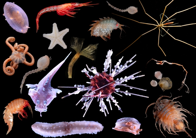
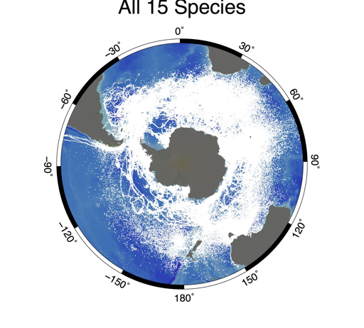
The Retrospective Analysis of Antarctic Tracking Data (RAATD) is a multispecies assessment of habitat use of Antarctic meso- and top predators in the Southern Ocean based on existing animal tracking data to identify Areas of Ecological Significance, i.e. regions that are important for foraging to a range of predators and which, consequently, present an important biodiversity. RAATD was initiated by the SCAR Expert Group on Birds and Marine Mammals (EG-BAMM), and provides (i) a greater understanding of fundamental ecosystem processes in the Southern Ocean, (ii) facilitate future projections of predator distributions under varying climate regimes, and (iii) provide input into spatial management planning decisions for management authorities such as the Convention on the Conservation of Antarctic Marine Living Resources. The synopsis of multi-predator tracking data will also expose potential gaps of data coverage in regions or seasons that are important but underrepresented, possibly due to biases in the spatial, temporal, or taxonomic distribution of research effort. We have collated all available tracking data by research groups that worked in the Antarctic since the 1990s. We have then establish a preliminary publicly accessible repository of these data. The final publicly available repository will only have the raw data that data holders have agreed to share and will contain data from almost 40 contributors from 12 national Antarctic programs. The dataset contains data on 17 predator species, with more than 3400 individual animals, and more than 2.5 million data points. We will also share the outputs of the project, including filtered and processed versions of these data, and habitat model outputs.


Un coup d’oeil a la biodiversite des fonds marins Antarctiques

Que faisons-nous?

Nous sommes à bord du JCR, le James Clark Ross, un navire de recherche océanographique Britannique, qui doit son nom à un explorateur polaire Anglais.

JCR

Le James Clark Ross, a Signy Island. Photo: Bruno Danis

Le but de notre mission est de faire un inventaire, une liste, de tous les animaux qui vivent au fond de la mer (on les appelle les animaux benthiques), dans la région des Orcades du Sud. Ces îles se trouvent entre l’Amérique du Sud et la Péninsule Antarctique, et nous pensons que leur biodiversité doit être protégée. Pour cela, il est important de répertorier tous les animaux qui s’y trouvent (et beaucoup n’ont pas encore été décris), avec comme idée de pouvoir revenir plus tard pour un nouvel inventaire, qui permettra de déceler des changements dûs aux changements de l’environnement.

Comment faisons-nous?

Nous sommes dans une région qui a été relativement peu explorée. La seule manière d’inventorier les animaux qui nous intéresse est de les remonter à la surface. Nous utilisons pour cela des engins semblables à ceux qui sont utilisés par les pêcheurs, mais beaucoup plus petits, pour éviter d’abîmer les fonds. Nous utilisons notamment un AGT (Agassiz Trawl – Chalut Agassiz, du nom de son inventeur) et un traîneau EBS (Epibenthic sledge), qui permet de récolter les animaux qui sont près du fond. Avant de lancer les engins de récolte, nous “scannons” le fond, à l’aide d’un SWATH (qui permet d’avoir une image 3D du fond, très précise), qui fonctionne sur le principe de l’écholocalisation, comme les dauphins ou les chauve-souris… Nous utilisons ensuite une caméra benthique, qui nous permet de prendre de belles photos du fond. Une fois certains que les conditions sont réunies, nous déployons les engins depuis le pont arrière, et déroulons les cables pour atteindre des profondeurs de 500, 750, 1000, 1500 et 2000 m.

Swath3-300x233

Capture d’ecran du SWATH en action. Les couleurs sont proportionnelles a la profondeur (bleu: plus profond; rouge: moins profond). Photo: Louise Allcock.

Nous remontons ensuite les engins et trions et identifions tous les animaux, ce qui représente un travail très intense, que nous réalisons en équipe.

AGT

Lancement du chalut Agassiz depuis le pont arriere du JCR. Photo: Bruno Danis

Tri des echantillons

Une fois a bord, les echantillons sont tries dans le “WetLab”. Photo: Richard Turner

Qu’avons nous trouvé jusqu’ici?

Nous sommes à la moitié de l’expédition, et les différents endroits où nous avons travaillé (que l’on appelle des stations) montrent une diversité très différente. Certaines stations sont relativement pauvres en animaux, mais d’autres sont très riches, et nous avons probablement déjà récolté un nombre important de nouvelles espèces! Ce que nous accumulons comme information devra nous permettre de bien choisir les endroits qui doivent être protégés.

Biodiversity

Quelques animaux recoltes au cours de la campagne. Photos: Claudio Ghiglione, Camille Moreau, Helena Wiklund, Cath Waller


Pour en savoir plus… suivez le hashtag #SoAntEco sur Twitter


The White Island Blitz

Seawater of the Future?


This post is a press release from the University of Otago related to White Island expedition, to which the Marine Biology Lab of the ULB is participating.

In the first week of December a team of scientists [including Antonio Agüera] from all over the world will descend on Whakatane in the Bay of Plenty. These chemists, biologists, geologists, botanists and marine scientists are planning a “blitz” on the nearby marine volcano: Whakaari or White Island. Their aim: to find out as much as they can about the currents, the water, the algae, and the marine animals as they can in one week. White Island is special because the volcano heats up the water and bubbles carbon dioxide into it, through vents on the flanks of the volcano. This creates a marine environment that is warmer and more acidic than “normal” seawater – the kind of environment that we can expect to see as CO2 in the air is absorbed by the oceans over the next several decades. In effect, it creates Seawater-of-the-Future.

Scientists have been looking at the effects of warming and acidification on plant, animals and even ecosystems in the lab, but there are serious limitations to that kind of study. Having a real-life lab, where animals and plants have lived their whole lives in Seawater-of-the-Future, makes a big difference.

“We need to know more about how this kind of environment varies over time,” says expedition leader Dr. Abby Smith. “We hope to find out where the water is warmest, and where the bubbles make the water the most acid. This work will form the baseline for further studies, and allow scientists to plan their studies better. The best way to find out more about White Island is for us to go there all together.”

The White Island Blitz is being organised through the University of Otago Ocean Acidification Research Theme. Most of the 17 scientists who are coming along are from University of Otago or from the University of Auckland, but there are participants from Australia, Belgium, and the UK as well. This scientific expedition will take place in the first week of December, with fishing boats, divers, snorkelers, and a variety of equipment and samplers going out 48 km offshore to White Island for four days.

On Monday November 30 the Whakatane community and media will have a chance to meet the scientists and hear more about the expedition. And throughout the week a community engagement programme will invite locals, including tourism operators, teachers, and school children to learn more about their marine environment.

For further information contact, [or contact us directly]:

Associate Professor Abby Smith, Department of Marine Science, University of Otago

Chief Scientist of Expedition

Abby.smith@otago.ac.nz

Sally Carson, Department of Marine Science, University of Otago

Community Engagement Coordinator for Expedition

Sally.carson@otago.ac.nz

A review of the Biogeographic Atlas of the Southern Ocean

A review of the Biogeographic Atlas was recently published by John Davenport in Antarctic Science.

Here are a few quotes from the article you can find online.

“The Biogeographic Atlas of the Southern Ocean is a milestone product of 21st century Antarctic Science. ”

“It is an excellent showcase of the value of modern scientific power combined with co-operative and altruistic endeavour. ”

On the other hand, the SCAR Newsletter just published a focus on the Biogeographic Atlas.

New paper in Advances in Polar Science

A new paper by lead author Angelika Brandt was recently published in Advances in Polar Sciences. The paper addresses the main issues faced in the framework of deep-sea biodiversity monitoring:

Despite recent progress in deep-sea biodiversity assessments in the Southern Ocean (SO), there remain gaps in our knowledge that hamper efficient deep-sea monitoring in times of rapid climate change. These include geographical sampling bias, depth and size-dependent faunal gaps in biology, ecology, distribution, and phylogeography, and the evolution of SO species. The phenomena of species patchiness and rarity are still not well understood, possibly because of our limited understanding of physiological adaptations and thresholds. Even though some shallow water species have been investigated physiologically, community-scale studies on the effects of multiple stressors related to ongoing environmental change, including temperature rise, ocean acidification, and shifts in deposition of phytoplankton, are completely unknown for deep-sea organisms. Thus, the establishment of long-term and coordinated monitoring programs, such as those rapidly growing under the umbrella of the Southern Ocean Observing System (SOOS) or the Deep Ocean Observing Strategy (DOOS), may represent unique tools for measuring the status and trends of deep-sea and SO ecosystems.

Citation: Brandt, A., Griffiths, H., Gutt, J., Linse, K., Ballerini, T., Danis, B., & Pfannkuche, O. (2014). Challenges of deep-sea biodiversity assessments in the Southern Ocean. Advances in Polar Sciences, 25(3), 204–212. doi:10.13679/j.advps.2014.3.00204

The SCAR Biogeographic Atlas of the Southern Ocean

_77118968_photo-48

The SCAR Biogeographic Atlas of the Southern Ocean has been officially launched at the SCAR Open Science Conference in Auckland, New Zealand. The Marine Biology Lab of the ULB has been heavily involved in the effort, mainly in the edition, data mobilization and writing of the book.

You can download the first chapter of the Atlas as a preview.

Below is the press release, as prepared by the British Antarctic Survey.

The new Atlas, providing the most thorough audit of marine life in the Southern Ocean, is published this week by the Scientific Committee on Antarctic Research (SCAR). Leading marine biologists and oceanographers from all over the world spent the last four years compiling everything they know about ocean species from microbes to whales.

It’s the first time that such an effort has been undertaken since 1969 when the American Society of Geography published its Antarctic Map Folio Series.

In an unprecedented international collaboration 147 scientists from 91 institutions across 22 countries (Australia, Belgium, Brazil, Canada, Chile, Denmark, France, Germany, Ireland, Italy, Japan, the Netherlands, New Zealand, Norway, Poland, Portugal, Russia, South Africa, Spain, Switzerland, the UK and the USA) combined their expertise and knowledge to produce the new Biogeographic Atlas of the Southern Ocean.

More than 9000 species are recorded, ranging from microbes to whales. Hundreds of thousands of records show the extent of scientific knowledge on the distribution of life in the Southern Ocean. In 66 chapters, the scientists examine the evolution, physical environment, genetics and possible impact of climate change on marine organisms in the region.

Chief editor, Claude De Broyer, of the Royal Belgian Institute of Natural Sciences, said:

“This is the first time that all the records of the unique Antarctic marine biodiversity, from the very beginnings of Antarctic exploration in the days of Captain Cook, have been compiled, analysed and mapped by the scientific community. It has resulted in a comprehensive atlas and an accessible database of useful information on the conservation of Antarctic marine life.”

The data, and expert opinions, in the Atlas will help inform conservation policy, including the debate over whether or not to establish marine protected areas in the open ocean. Sophisticated environmental models coupled with existing species distribution data provide a valuable outlook on the possible future distribution of key species as they adapt to climate change.

New advances in genetics have shed light on some of the best known species from the Antarctic sea floor. The giant isopod crustacean Glyptonotus antarcticus is one of those. The animal lives on the edge of the continent at depths of up to 600 metres. Previously considered to be a single species with a circumpolar distribution, molecular barcoding suggests it may, in reality, be a group with up to eleven species inhabiting much smaller geographic regions.

Author, and editor, Huw Griffiths, of the British Antarctic Survey, said:

“The book is unique and contains an amazing collection of information and photos. It’s been an enormous international effort and will serve as a legacy to the dedicated team of scientists who have contributed to it. The Atlas is a must-read for anyone interested in the animals living at the end of the Earth.”

The Atlas contains around 100 colour photos and 800 maps. It will be launched at the SCAR 2014 Open Science Conference in Auckland, New Zealand on Monday 25th August.

BIOMAR Lab hosting mARS workshop

This week, we are hosting another workshop to scope out the next steps for the Microbial Antarctic Resources System (mARS) , a followup project from SCAR’s Expert Group on Antarctic Biodiversity Informatics (EG-ABi).

The participants include Alison Murray (Desert Research Institute), Anton Van de Putte (biodiversity.aq), Nabil Youdjou (biodiversity.aq) and Bruno Danis (Marine Biology Lab). PhD students from the CCAMBIO project also attended, as beta-testers.

The Microbial Antarctic Resources System (mARS) is envisioned as an information system dedicated to facilitate the discovery, access and analysis of geo-referenced, molecular microbial diversity (meta)data generated by Antarctic researchers, in an Open fashion. The scope of diversity will encompass all freel-living and host-associated virus, Bacteria, Archaea, and singled-celled Eukarya.

mARS focuses on past, present and future works. It offers a community-driven platform for scientists to publish, document, analyse and share their (meta)data with the broad community for science, conservation and management purposes, in the spirit of the Antarctic Treaty.

This week, we will  be beta-testing the mARS to take it to Step 3, as described in our vision document.

BIOMAR Lab hosting dBASO workshop

atlas_home

This week, we will be hosting an international workshop to scope out the new dynamic Biogeographic Atlas of the Southern Ocean (dBASO), a followup project of SCAR’s Biogeographic Atlas of the Southern Ocean.

At the end of five years of extensive biodiversity exploration and assessment by CAML and the OBIS Antarctic Node (the SCAR Marine Biodiversity Information Network), a new initiative, the multi-authored “SCAR Biogeographic Atlas of the Southern Ocean”, has been established under the aegis of the Scientific Committee on Antarctic Research (SCAR) to provide an up-to-date synthesis of Antarctic and sub-Antarctic biogeographic knowledge and to make available a new comprehensive online resource for visualisation, analysis and modelling of species distribution. It will constitute a major scientific output of CAML and SCAR-MarBIN as well as being a significant legacy of CoML and the International Polar Year to fulfill the needs of biogeographic information for science, conservation, monitoring and sustainable management of the changing Southern Ocean. It will be of direct benefit to the Antarctic Treaty and associated bodies such as the Convention for the Conservation of Antarctic Marine Living Resources.

Ten participants from 5 countries (Australia, France, Italy, United Kingdom, Belgium) will be working on the initial development steps to make dBASO go live.


Biomar Lab hosting mARS workshop

This week, we will be hosting a hands-on workshop to push the mARS project further, with Alison Murray (Desert Research Institute), Anton Van de Putte and Nabil Youdjou (biodiversity.aq project)

The Microbial Antarctic Resources System (mARS) is envisioned as an information system dedicated to facilitate the discovery, access and analysis of geo-referenced, molecular microbial diversity (meta)data generated by Antarctic researchers, in an Open fashion. The scope of diversity will encompass all freel-living and host-associated virus, Bacteria, Archaea, and singled-celled Eukarya.

mARS focuses on past, present and future works. It offers a community-driven platform for scientists to publish, document, analyse and share their (meta)data with the broad community for science, conservation and management purposes, in the spirit of the Antarctic Treaty.

mARS is composed of interoperable modules, iteratively building the microbial component of the biodiversity.aq network.
To the best extent possible, the wishes of the community regarding mARS functionalities will be reflected in the flexibility and scalability of the system. Feedback is expected from the users community in order to align their needs and the functionalities of mARS.

This week, we will  try to get through Step 3 of the mARS system and prepare for Step 4 once we have enough data in mARS to make it worthwhile.

mARS steps include:

1. Data description and discovery

2: Habitat and Microbial Sequence Metadata Entry (MiMARKS Data Standard; Microbial_Sequence_Set_Template)

3: Georeferenced-molecular sequence database integration

4: Processing batch sequence data –Circum-Antarctic microbial diversity

You can find more on the mARS white paper page.


Mission Portman: a short report…

Remediation poster

Poster explaining the ongoing remediation programs in the Bay Portman

A small team from the BIOMAR Lab set a research mission to the Bay of Portman, Spain. The team was composed of Philippe Pernet (technician), three master students (Valérie Rossez, Andrea Garvetto and Maxime Coupremanne) under the supervision of Bruno Danis. The team reached the Bay on October 16th, 2013 for a 10-day stay.

The Bay of Portman was chosen for its exceptional environmental characteristics, from a contamination standpoint. A conference was recently held on the subject, involving our colleagues Drs Maria Jose Martinez and Carmen Perez, both from the Research Group of Soil Pollution in the University of Murcia.

A series of sampling and measurement were carried out in the framework of the master students respective projects:

Valérie Rossez worked on  comparative acid-base physiology  in two species of sea urchins (Paracentrotus lividus and Arbacia lixula), investigating the relationship between this physiological parameters and the uptake of contaminants but the sea urchins

Paracentrotus lividus (image from Encyclopedia of life, www.eol.org)


Arbacia lixula

Arbacia lixula (picture from Encyclopedia of Life, www.eol.org)

Andrea Garvetto worked on microbial diversity, and took samples to investigate the link between the levels of contamination and microbial community structure in digestive pellets of two species of sea urchins (Paracentrotus lividus and Arbacia lixula), in various algae as well as in the seawater and sediments (various granulometries).

Maxime Coupremanne carried out a fine-scale mapping of the biodiversity and habitats of the Bay and its surroundings using underwater video transects using the lab’s ROV as well as videos shot by SCUBA divers.

Wally

Our ROV, Wally, in station S3, ready for deployment

Also, samples were taken for heavy metal levels analyses for each corresponding stations. The team was able to work in a total of 16 stations in the Bay, organised in a set of transects (from inside to outside the Bay as well as along the coast, following the main currents), and has come back to the Lab to process the samples. This pool of samples and video transects constitutes a unique benchmark to address potential future changes, for example in the mining activities of the Bay of Portman.

sampling

Sampling station in the Bay of Portman